This five part series within the Secret Visitors Project will be updated irregularly – keep checking back or subscribe using the RSS feed.
– – – – – – – – – – – – – – – – – – – – – – – – – – – – – – – – – – – – – –
What are the facts about the Kariong hieroglyphs? Since they were first publicised two decades ago, a lot has been written about them, but actual facts have been fairly rare in this discussion, heavily outweighed by vague ponderings and wishful thoughts repeated on the internet until people believed they must be true. I’ll stick to what we really know.
The conclusions
I’ll put the punchline right up front where everyone will get it, rather than wading through to the end. This is what the facts tell us about the Kariong site.
- The Kariong hieroglyphs are recent in age. All the archaeological, geological and other evidence points to them being produced over a period of no more than 20 years from the 1960s through to the last ones in the early 1980s. The people who produced the glyphs are not known.
- They are unlikely to be more than 50 years old. No matter how much the claims are pushed, no evidence has been brought forward that is completely inconsistent with the 50 year maximum date. Unsubstantiated claims from locals and people who ‘just reckon’ are of no value as evidence.
- The hieroglyphs cut into the rock at the main site and at a few locations nearby were the work of at least two people, maybe more, and new symbols were added at different times over more than a decade. Apart from the glyphs themselves and some demonstrably recent illegal digging, almost everything that has been put forward as ‘evidence’ has been a misinterpretation of natural features of Hawkesbury sandstone. There is not one of these natural features that cannot be found occurring many, many times elsewhere in the Sydney Basin.
- The three [or more] ‘translations’ of the hieroglyphs are all likely to be wrong, as there is no evidence that it is more than a random assemblage of symbols. Making a story from them is no different to making a narrative from a string of shopfront names or words randomly picked out of a hat.
- Egyptologists have identified many discrepancies between the glyphs and Egyptian writing of the claimed period. Attempts to match the story to features of the site are weak and the named noblemen alleged to have made the voyage do not exist in Egyptian records.
- While a lot of people are pushing for the authenticity of the site – Rex Gilroy, Steve Strong, Hans von Senff and Paul White most notably and publicly – each disagrees with the other about dates, translations, meaning and origins. They can’t all be right, but all of them could be wrong.
- The hieroglyph site is within Brisbane Waters National Park. It is not under direct threat from the proposed Bambara Road housing development, although is often claimed that it is. Certainly increased housing nearby will place a lot of unwanted pressure on the national park and other land that needs protection. Increased visitor numbers could present a risk to the site by encouraging graffiti and vandalism.
- There is no conspiracy or cover-up. National Park managers are concerned when people use metal detectors or excavate the ground – both are illegal within national parks, and there are real public safety issues to consider as well. Most archaeologists avoid getting involved in this sort of stuff because they find the claims laughable, and dislike wasting their time arguing with people who are very unlikely to change their minds, even when the gaping holes in their evidence and logic are shown to them.
- It is also within a registered Aboriginal Place, which received special protection under the NSW National Parks and Wildlife Act 1974. Anyone visiting the site should only aim for the ideal of only taking photos and leaving only memories. Unauthorised ‘research’ including digging could result in heavy penalties.
- Many people believe – based on no evidence – that Egyptian ships could have travelled to Australia. All the evidence from archaeological finds of actual ships shows they were best suited to rivers and sea-going, not open ocean. There are no, repeat, NO legitimate ancient finds of any Egyptian items east of the Horn of Africa, apart from the dubious claims for the Kariong glyphs and other similar items from around Australia.
Presenting the evidence in the sort of detail required takes up a lot of space. I’ve done the following as a sort of Frequently Asked Questions list. There are links to relevant discussions on my site and elsewhere, rather than the usual detailed referencing which I do elsewhere. This is for readability, but if you need to track something specific down, please ask. Some parts are still in preparation and will be added to as I go. Please keep checking back for updates.
The rest of this article and the full list of topics is split over four further parts:
1. What is the Kariong Hieroglyphs site?
2. When did people first know about the site?
3. Could the inscriptions be older than the 1960s?
4. Why were they made?
5. What is the geology of the site?
6. Putting a date on the engravings?
– – – – – – – – – – – – – – – – – – – – –in Part 2 – – – – – – – – – – – – –
7. Were the engravings protected from weathering?
8. Could the engravings have been re-cut, so they appear fresh?
9. Is there an underground chamber or tomb?
10. Do the glyphs tell a coherent story?
– – – – – – – – – – – – – – – – – – – – –in Part 3 – – – – – – – – – – – – – –
11. Did the Egyptians know of Australia?
12. Could Egyptians have sailed to Gosford in eastern Australia?
13. Is there a conspiracy to deny the existence of this site?
14. Could evidence of Egyptian presence be removed or concealed?
– – – – – – – – – – – – – – – – – – – – –in Part 4 – – – – – – – – – – – – – – –
15. Does the Government want to keep it under wraps for sovereignty?
16. Are Aboriginal people keeping their knowledge secret because it undermines their land rights?
17. What do believers in the site say happened?
– – – – – – – – – – – – – – – – – – – –in Part 5 – – – – – – – – – – – – – –
18. Aren’t there experts who support the authenticity of the engravings?
19. What do the experts think?
20. Is there any other evidence of Egyptian presence in Australia?
21. Now, convince me.
22. Conclusion.
23. References.
– – – – – – – – – – – – – – – – – – – – – – – – – – – – – – – – – – – – – – –
1. What is the Kariong Hieroglyphs site?
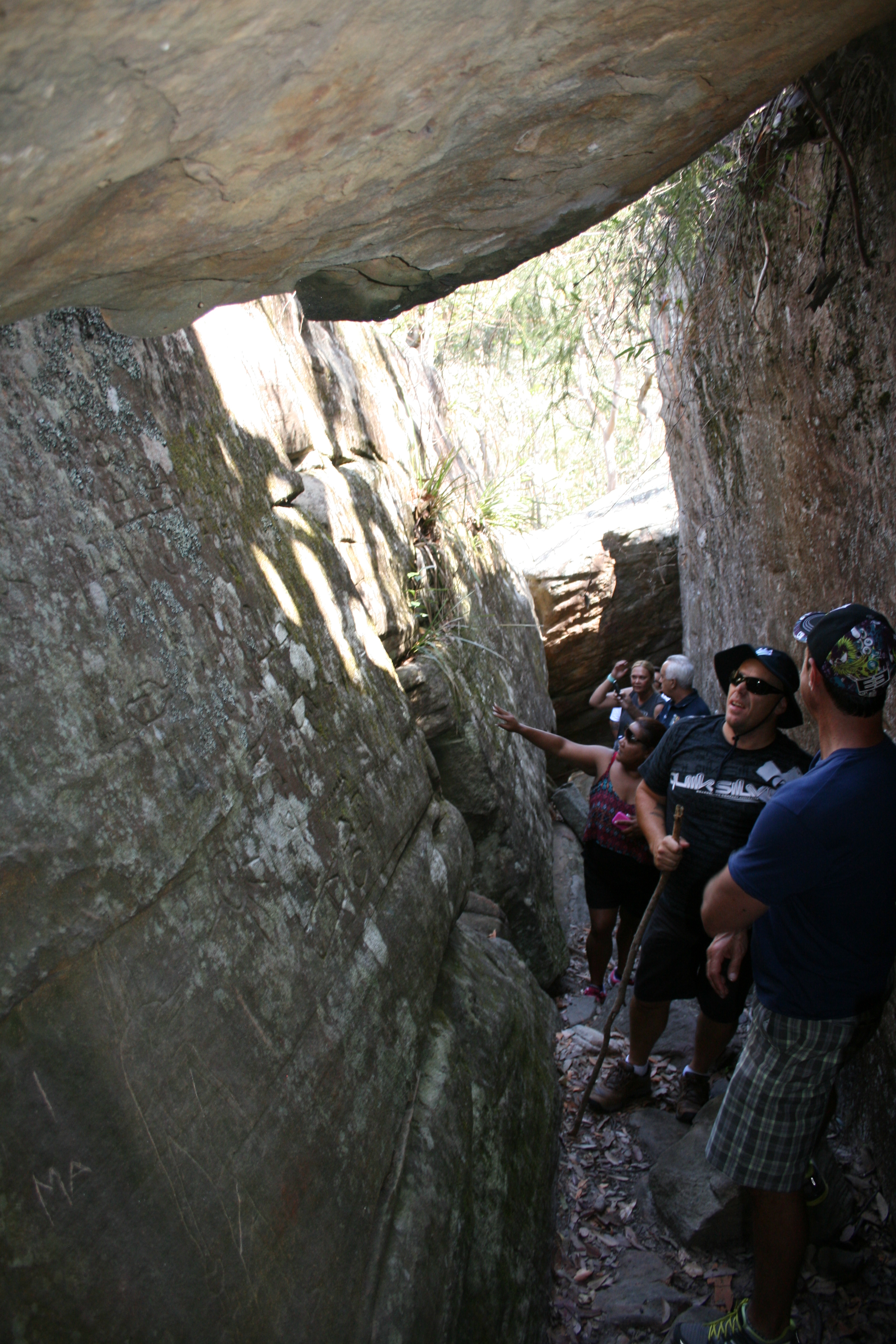
The Kariong hieroglyphs site consists of a narrow cleft in a sandstone plateau near Gosford, north of Sydney [Fig 1]. Both sides of the cleft contain engraved Egyptian hieroglyphs, and similar motifs are also found in a few other locations nearby. Fractured stone beneath the cleft is claimed to conceal buried passages or a ‘tomb’. Advocates – the people who believe in the authenticity of the hieroglyphs – claim they were cut about 4,500 years ago by an expedition that travelled from Egypt. Other natural features nearby have been re-intepreted and woven into the story along with other claimed evidence for an unrecorded Egyptian presence in Australia.
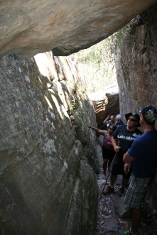
People inspecting the alleged ‘hieroglyphs’ on both sides of the narrow stone cleft.
The glyphs are in Brisbane Waters National Park, about an hour’s drive north of Sydney near Gosford, followed by a half-hour walk. The NSW National Parks and Wildlife Service [NPWS] considers that the engravings are very recent. As it is national park, any site visitors are bound by the park rules to not damage any plants, animals, Aboriginal or non-Aboriginal heritage or geology. Lighting fires, using metal detectors or disturbing the ground surface is prohibited, along with removing anything found in the park.
On 22 February 2013 the land was declared as the Kariong Sacred Land Aboriginal Place, a category of protection under the NSW National Parks and Wildlife Act 1974 that covers both national park and private land. The statement of significance supporting the listing reads [in part]:
Kariong Sacred Lands is a site with rich Aboriginal history and evidence of long occupation and use by Aboriginal people. The area has traditional teaching places and is used for the continuing education of youth, both Aboriginal and non Aboriginal.
Aboriginal Elders continue to use the area as a ‘bush schoolroom’, where they teach the younger generations about Aboriginal history, traditional stories, how to interpret the engravings and rock paintings and about traditional practices such as collecting and using bush foods and natural medicines that abound the area. The area is highly valued by the Darkinjung, Awaba and Gurringai peoples of the Gosford region for its natural beauty where elements of the vegetation, rock formations and art add to the aesthetic and spiritual value of this site. [NSW Govt Gazette 8/2013 – 22 Feb 2013, p. 464]
Academic opinion among archaeologists, including specialists in Australian archaeology, Egyptology and the study of pseudoarchaeological claims is also consistent in considering that they are of recent age. I am confident they date to no earlier than the 1960s. Evidence of this date is set out below.
There are many photos of the site available on the internet. Good quality collections include [Bob Clutton’s site][Paul Clacher’s site] or just type in Kariong, Gosford and Egyptian into Google Images search to find many more.
For those who crave moving pictures, there are hours of footage shot by people with video or even phone camera. The full list of You Tube clips can be found at [Part 1] [Part 2] [Part 3] [Part 4].
2. When was the site first known about?
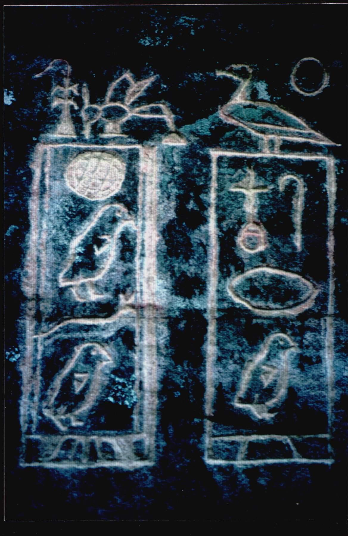
The site was known to NPWS staff from at least the late 1970s. A NPWS rock art conservation specialist, Dave Lambert, took photos of freshly carved parts of the inscription in 1983. Trained in geology, he is the author of one of the important early rock art conservation guides, used internationally [Lambert 2007]. His main expertise has been on Sydney sandstone country sites. The photos he took showed some of the engravings exposing stark white unpatinated stone immediately beneath the surface [Fig 2]. This tells us two things – firstly that the engraving of that figure had just been done, and that the stone surface itself was not of an age to develop a deep weathering crust either.

Freshly cut cartouches
The site came to public attention when film-maker Paul White of Network 23 Productions published an article in Nexus [April-May 1994, pp.16-20]. His company had already produced ‘The mystery of the Earth Grid’ and ‘Journey to the Vortex’, and the article coincided with the release of another 30-minute documentary ‘The Egyptian connection’. White added another article in Exposure [vol. 2, no. 6, 1996, pp. 20-7]. This featured Ray Johnston’s initial translation of the engravings.
The earliest mention of the existence of the engravings I can find is from the early 1970s, which suggests that they may have been there in the late 1960s. A Gosford Council employee visited them several times in the 1970s. He said that initially they were on one wall of the cleft, but started being added to the second wall. There is also an account by bushwalkers that probably refers to them at a similar date. This is as far back as I can push knowledge of the site.
Occasional statements have appeared that the site was known about ‘by locals’ or others for a much longer period. None of these has ever been backed up with any convincing evidence. Steve Strong made great play that a woman who grew up locally was willing to put together a statutory declaration that in 1958, more than 50 years ago, as a 10 year old girl, she visited the location with her uncle. The stat dec is only found on another site, and seems removed from Steve Strong’s own. I have found that peoples’ recollections of matters half a century earlier are questionable at best. I particularly cannot rely on someone who may have been so young that they were definitely at the site. They clearly visited a number of Aboriginal sites but her recollection of the glyphs is to vague to be convincing.
3. Can the glyphs pre-date the 1960s?
Advocates make great play of the site being in the depths of wild bush. It is actually within 100 metres of a public road and during the first part of the 20th century the land immediately to the south was subdivided. A house owned by Mr E.F. Gilford stood within 200 metres of the site, and it was occupied until the 1960s [see map here]. Further info on Gilford’s property has been compiled by Alan Gresley.
Gilford was an enthusiast for the Aboriginal rock art in the area, but never made mention of them. The Aboriginal engravings have attracted many rock art recorders since the late 19th century. All of them have clambered through this area looking for new sites. Not one of them ever mentioned the existence of the site, including Mr Gilford. One rock art recorder, A.J. Vogan, even advertised in the local newspaper in the 1930s, during the Great Depression, offering a reward for unusual engravings. No one came forward with the glyph site.
If the hieroglyphs had existed before the late 1960s they were capable of being found by any one of a number of highly experienced Aboriginal rock art recorders who worked in that area, specifically looking for rock engravings.
4. Why were they made?
As we do not know who began the carvings or added to them, understanding their motivation is not possible. Technically it is not a hoax, as there was no intent to pass off or claim them as something they were not and they were never publicised by their maker[s]. However, they have tricked people into believing their authenticity, but that is more a reflection of the credulity of some people than any intention to deceive.
5. What is the geology of the site?
The site is within the Sydney Basin. The main sandstone formation is known in this locality as the Terrigal Formation, which is equivalent to the Narrabeen Sandstone further south. It is overlain by Hawkesbury Sandstone, which survives mainly on the ridgetops and as isolated knolls. The glyph site is in the lower part of the Hawkesbury Sandstone, at about 190 metres elevation above sea level.
Despite many claims to the contrary, all of the splitting of stone blocks into flattened slabs, differential weathering, and apparent placement of stone forming the cleft and the rock structure above and below it is caused by well-understood and completely natural geological processes. The same processes can be seen in great variety throughout the surrounding bushland, and occur many hundreds, probably thousands of times over throughout the Sydney Basin. Many people who have visited the site clearly have not observed the country they have just walked through, when they claim some geological feature as ‘unique’.
Some of the many wrong comments made about the geology of the site include:
The stone is basalt – No, it is sandstone, part of the Hawkesbury Sandstone which extends over hundreds of kilometres in the Sydney Basin.
The sides of the walls are finely chiselled – No, these lines are natural cross-bedding marks from the flow of sand-laden water within a river system more than 200 million years ago. Identical cross-bedding is visible in almost every road-cutting or exposed piece of bedrock within the Sydney Basin.
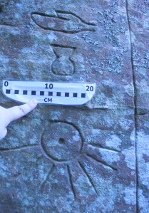
The glyphs are very eroded – No, they are not. Nearly all have fine sharp edges. Erosion rates for Sydney sandstone range from 13-17 mm per century or about half a sand grain per year. Over 3,000 years the surface of the sandstone would have weathered down at least 390 – 510 mm, that is around half of a metre. Even a reduced rate would have seen the loss of the engravings many times over.
The glyphs are not eroded but remain sharply defined and fresh
The cleft with the glyphs was deliberately formed – No, the cut is part of the natural erosion process for Hawkesbury sandstone, where the edges of the plateau calve into blocky fragments, leaving parallel-sided gaps between bedrock and boulder. These widen as gravity moves the boulder further away and vegetation and slope-wash fill in the growing gap. Eventually the east wall, the calved and detached boulder, will move outward enough that it will tumble into the valley floor. The large block resting across the cleft from the next layer above is also pressing down on the lower blocks and hastening their collapse.
The walls are preserved with a geopolymer resin, as used by ancient Egyptians – This statement is not backed up by any evidence. About 30 years ago geochemist Joseph Davidovits put forward that the ancient Egyptians used artificially manufactured stone to build the pyramids. This idea has been rejected by Egyptologists, and is contradicted by other evidence for pyramid construction. His claims for geopolymer resin have never received support from anyone familiar with Egyptian stoneworking.
There is a shaped trough near the site – This is exposed natural ironstone banding which can result in some layers within sandstone becoming very erosion-resistant compared to adjoining layers of sandstone. The wavy surface is a giveaway to the fluvial [riverine] origins of the sandstone bedding.
6. So, how old are the engravings?
Taking all of the evidence together, they were carved over a period from the 1960s to 1984. They are at most about 50 years old.
The lines of evidence that support the date of 50 years maximum are:
Condition of the engravings – The edges of the engravings are sharp and made with hard chisels leaving clean V shaped cuts. Close examination shows no sign of any re-cutting.
Lack of erosion – There is no sign of the erosion that would have been present over more than 3,000 years or even 450. Even if the erosion rate of 13-17 mm per century were reduced somehow by 99%, the 3.9-5.1 mm of weathering would be clearly visible on the edges of every cut. Any more than 10 mm of erosion and many of the figures would be rendered illegible.
Lichen growth – There are two main types of lichen growing on the sides of the cleft – a green circular lichen – Xanthoparmelia – and a lighter one with black ‘peppery’ spots – Buellia. Symbols were cut through the Xanthoparmelia lichen and they have not in any instance had time to re-colonise the cuts. Comparison with examples on different surfaces and moisture conditions shows highly variable growth for this lichen. The thallus [central body] grows about 5 mm in radius every 30 years, or 15 mm per century. The Buellia lichen grows about twice as fast as Xanthoparmelia. Xanthoparmelia has not re-colonised any of the engraving cuts where it has been severed but Buellia has.
The oldest lichen in the cleft is only several centuries old at most and is not found in the engravings. It is likely to reflect the relative age of the crack, suggesting it only formed a few hundred years ago. The precarious position of the overlying boulder suggests its separation and eventual collapse is still a work in progress.
Comparison with other sandstone construction of similar or greater age – We can easily compare dated sandstone headstones or buildings throughout Sydney to see how it fares over 50 years or a century. We can also look at Aboriginal engravings, including a number within a short distance at the public site of Bulgandry, which are a minimum of two centuries old. We can examine the convict-built Great North Road from the 1830s. In comparison with the Kariong engravings, on exactly the same sort of stone, any stonework over a century old is much more deteriorated. The Kariong engravings are clearly younger than that.
Lack of knowledge by landholders, occupants and others looking for art sites – The dating is also completely consistent with the lack of knowledge of the engravings by the landholder and occupants who lived a few hundred metres away from the engravings and the collective activities of many professional and experienced amateur rock art recorders. Even the offer of a cash reward in the local newspaper during the 1930s, the height of the Great Depression, did not get any information on the site. Although negative evidence is always less than conclusive, these are very strong factors that should have resulted in the discovery of the site if it were present.
– – – – – – – – – – – – – – – – – – – – – – – – – – – – – – – – – – – – – – – – – – –
Part 2 follows here. It deals with the following topics:
7. Were the engravings protected from weathering?
8. Could the engravings have been re-cut, so they appear fresh?
9. Is there an underground chamber or tomb?
10. Do the glyphs tell a coherent story?


 Posted by The Secret Visitors Project